About the Project
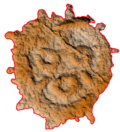
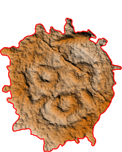
The Russian Far East is a unique natural and historical region of Northeast Asia. Here, along the banks of the Amur River, one of the largest rivers in the world, there are hundreds of archaeological sites that have preserved the life of ancient tribes and peoples for millennia. Among the numerous archaeological sites found in the 19th and 20th centuries in the valley of the Lower Amur, a special place is occupied by sites of rock art – petroglyphs made on separate laying boulders and vertical rock outcrops. A number of sites with similar historical, cultural, technological, and artistic characteristics are united in the Amur-Ussuri province of rock art. The most extensive site is located on the right bank of the Amur River below the city of Khabarovsk, in the Nanai village of Sikachi-Alyan. Two more satellite rock art site are located on the Kiya River (Chertovo Pleso locality) and on the Ussuri River near Sheremetyevo village.
Since autumn 2016, the location of the petroglyphs of the Amur region has been documented by the research team of Paleolithic Art Center of the Russian Academy of Sciences, the Khabarovsk Regional Heritage Preservation Center, and the RSSDA Laboratory. During these years, Moscow and Khabarovsk researchers have worked together to digitize almost completely complex monuments of rock art that differ in their technological identity.
Most important results of work
- All known and currently accessible sites of rock art of the Amuro-Ussuri province have been comprehensively documented.
- The research materials of the late 19th and early 21st centuries have been systematized and consolidated into a single database.
- The spatial position of all documented stones and surfaces was recorded, geoinformation systems of individual monuments were formed.
- Petroglyphs that have been described by past researchers without precise reference to the terrain and are considered lost have been identified.
- Previously unknown petroglyphs have been identified, including on known rocks and surfaces.
- A petroglyph imaging technique, optimized for images of poor preservation on basalt boulders and surfaces, has been developed.
- A method of mapping petroglyphs on rock cliffs has been developed.
- A monitoring methodology for the boulders movement including objective data on horizontal and vertical displacement in the Amur River flood plain under the influence of ice drifts and floods has been developed and implemented.
The authors of the project
E. S. Levanova, A. R. Laskin, E. V. Romanenko, Y. M. Svoyskiy

The idea of the project belongs to the Scientific Secretary of the Institute of Archaeology of RAS Ekaterina Georgievna Devlet (1965-2018). All the participants in the project are sincerely grateful to her for initiating such complex and interesting work, which we have tried to do at the highest level.
This project was carried out thanks to the assistance and support of our colleagues: O. S. Sovetova, G. G. Korol, E. A. Miklashevich, E. S. Konakova, A. E. Grinko, E. D. Vyaznikova, V. V. Osadchuk, E. V. Chernikov, A. Babayev, I. Y. Georgievskiy, S. V. Peshkov, A. S. Peshkov, N. N. Chekunova, R. M. Khayrulin, V. V. Vasnev, A. A. Ziganshina, A. D. Kleimenov, L. A. Zholtysheva, E. V. Yushin, I. V. Abolonkova, E. A. Nikitina, A. A. Pichugina, A. P. Girich, A. B. Menshikov, D. M. Pavlov, E. A. Galkina.
For questions related to site operation, image use and scientific cooperation, please contact paleoartlab@gmail.com. We welcome the use of site materials – with obligatory reference to aurockart.ru.
Translated by M. L. Svoyskiy