Sikachi-Alyan

“On the right bank of the Amur, 60 versts below Khabarovsk, near the Gold village of Galbu, located 1 verst below the village of Mamyzhskoye, on the rocks on the very shore there is an image of an elk, a man with a dog in the field, wares, etc. The place can be shown by Golds Ekhtambu and Omu. Reported by staff captain P. Iv. Vetlitsyn, 1873 to Mr. Shevelev “.

F. F. Busse, L. A. Kropotkin, 1908

The group of sites of the Sikachi-Alyan petroglyphs is located on the right bank of the Amur River and the Malyshevskaya channel of the Amur River near the village of Malyshevo and the Nanai national village of Sikachi-Alyan (Khabarovsk District of the Khabarovsk Krai). As of 2020, six petroglyph locations are known within the group. Almost all the petroglyphs are made on separately lying basalt boulders, and only a small part of them is pecked or carved on the vertical rocky ledges of the basement terraces, also composed of basalts. Boulders are constantly moving under the influence of ice drifts and strong floods. The petroglyphs, based on a comparison of the features of the images with the materials of the archaeological cultures of the region, date from the Neolithic era (XIII – X millennium BC) to the early Middle Ages (IV – XIII centuries AD).

Sikachi-Alyan 2.
A security sign at the site of the petroglyphs.

In accordance with the Decree of the Council of Ministers of the RSFSR dated 04.12.1974 No. 624, the cultural heritage site “Sikachi-Alyan. Petroglyphs ”is a historical and cultural site of national importance. On the basis of the Decree of the President of the Russian Federation of 20.02.1995 No. 176, it is classified as an object of the historical and cultural heritage of federal (all-Russian) significance. Placed under state protection by the decision of the Executive Committee of the Regional Council of Working People’s Deputies No. 65 dated February 14, 1957. In 2019, the Sikachi-Alyan petroglyphs were included in the State Register of Especially Valuable Cultural Heritage Objects of the Peoples of the Russian Federation. In 2003 the site was included in the Provisional UNESCO List.

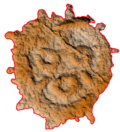
The petroglyphs of Sikachi-Alyan became known at the end of the 19th century thanks to the diary records of the Russian orientalist Palladiy Kafarov. Information about ancient drawings on stones was given to him, apparently, in 1870 by the Nanai Protodyakonov. Subsequently, the petroglyphs of Sikachi-Alyan were repeatedly visited, described, and partly documented by P. I. Vetlitsyn in 1888-1890, B. Laufer in 1899, L. Ya. Sternberg in 1910, Torii Ryuzo in 1919, N. G. Kharlamov in 1929-1930. and A. P. Okladnikov in 1935. Beginning in 1953, Sikachi-Alyan was investigated by A. P. Okladnikov’s expeditions; the most ambitious work on documenting the monument was carried out in 1958, 1963, and 1969. Based on the results of these expeditions, the books “Faces of the Ancient Amur” (1968) and “Petroglyphs of the Lower Amur” (1971) were prepared.

The location layout of petroglyphs
in the area of ​​the villages of Malyshevo and Sikachi-Alyan.
Okladnikov, 1971

The scientific study of the Sikachi-Alyan petroglyphs resumed in 2000 due to the awareness of the need to preserve the site. By this time, during the construction of the dam that blocked the Malyshevskaya channel, boulders with the Sikachi-Alyan 5 rock art site were completely lost. Survey of Sikachi-Alyan 1, 2, 3, and 4 by M. I. Gornova in 2000 and A. R. Laskin in 2003 showed that a significant part of the boulders described by A. P. Okladnikov on Sikachi-Alyan 1, 2, and 3 are not found due to their movement by ice drifts and floods. Boulders with petroglyphs at Sikachi-Alyan 4, due to a change in the hydrological regime of the Malyshevskaya channel, were buried in a layer of loose alluvium. Four boulders of Sikachi-Alyan 1 were saved by moving them to the surface of a high floodplain. In 2009, the site was re-examined by E. G. Devlet, E. Yu. Girya and A. R. Laskin (with facsimile copies of a number of images), but then the research was suspended for a few years.

The impetus for the resumption of large-scale fieldwork in Sikachi-Alyan was the catastrophic flood in 2013 when the water level in the Amur River reached a historical maximum (+808 cm). In the summer of 2014, under the leadership of E. G. Devlet and A. R. Laskin, the joint efforts of the Petroglyph Detachment of the Russian Academy of Sciences were carried out to clean up the site territory, to remove natural and domestic garbage, to clear stones from sediments on Sicachi Alyan 1, 2 and 4. One of the boulders of Sikachi-Alyan 4, completely covered with alluvium, was completely dug up and revealed for research. After an unsuccessful attempt to move it, a drainage system was laid around the boulder to discharge rain and floodwaters into the Amur River in such a way that sandy deposits here could decrease naturally. This, however, also did not give the desired result, and by now, this boulder is again buried in loose alluvium. In the process of cleaning stones at Sikachi-Alyan 1 and 2, new petroglyphs were revealed. 

The dam overlapping the Malyshevskaya channel,
during the construction of which the petroglyphs of Sikachi-Alyan 5 were filled in.
Alteration of the hydrological regime of the channel stopped its periodic “washing” during floods and led to the burial of boulders with petroglyphs at Sikachi-Alyan 4 with fine-grained alluvium.

Sikachi-Alyan 1

Sikachi-Alyan 2

Sikachi-Alyan 3

Sikachi-Alyan 4

In 2017-2019 with joint efforts of the Center for Paleo-Art of the Institute of Archeology of the Russian Academy of Sciences, the Khabarovsk Regional Heritage Preservation Center, and the RSSDA Laboratory, the documentation of petroglyphs and their landscape context was carried out. Aerial photography of all six locations within the protected zones was also carried out. Areas of distribution of boulders with petroglyphs in the floodplain on Sikachi-Alyan 1 and 2 and rocky cliffs of Sikachi-Alyan 3 and 4 have been mapped in detail. All known and accessible surfaces and boulders with drawings have been examined, their coordinates have been determined.

49 boulders and surfaces with petroglyphs are documented. Nine previously unknown boulders with petroglyphs and at least 10 poorly preserved images on the boulders previously described by A. P. Okladnikov were revealed. With the development of visualization methods, the identification of new petroglyphs continues.